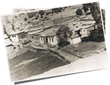
Uğurtaşı village is a highland village located within the borders of the Torul district of Gümüşhane province. Since this booklet is prepared with the assumption that people who know the region will mostly read it, detailed geographical information about the region is not given.
Geologically, we can say that the village is on a slip plane starting from the slopes of Gabena. Volcanic and granite rocks near Uğurtaşı have formed deep valleys like a trap. These valleys, on the other hand, narrowed at an angle of 35 degrees in the east-west direction, forming dense and regular forms such as sandstone, limestone and hardened clayey leaf stone.
In order to travel to Uğurtaşı village, it is necessary to use the road that leads north to Karaca cave from İkisu locality between Torul and Gümüşhane. This road has recently been both widened and paved. The distance between two of our villages is twenty-one kilometers. It is possible to reach our village from İkisu in thirty minutes by car. We can examine the transportation process to the village before the opening of this route in two ways, by car and on foot. See Annex 1.
It was possible to reach our village from Trabzon by car using various routes. We can list these routes as follows:
The part of route number one between Ayaser and Village was built by the villagers in 1951 under the leadership of Kasımoğulları, one of the residents of our village (especially between Kolat Mountain and Village).
Other options used by the residents of our village during the periods when there was no means of transportation to the village by car were as follows.
From Trabzon to Zigana via cars, after that, the route of Mount Zigana-Salih's coffeehouse (from Atalar-Zimera)-Lalacon-Ispele-Village was used by horses. In the 1950s, Gendarmerie Officer Kamil Efendi (one of the Karakullukists) from the Tufan family pioneered the keeping of the pedestrian path between Salih's (Atalar) cafe and the village.
Before 1870, when the Zigana Pass was not yet opened (1870) and there was no automobile, our village used the route Kulat-Karakaban-Maçka-Trabzon on foot. Thus, it was possible to travel from our village to Trabzon or from Trabzon to our village on foot in 15 hours. Since it was not easy to walk for such a long time, one would stay overnight in one of the inns on the road and continue on the way. As will be explained later, transportation was closed during the winter months due to seasonal difficulties. Many fatal cases occurred during the spring and autumn when transportation was possible even in difficult conditions.
We can write that the following route alternatives have been used for centuries for pedestrian transportation from our village to Gümüşhane or from Gümüşhane to the village. See Annex-2
It is known that the last of the transportation options mentioned above has been used for thousands of years. The Iran-Trabzon caravan route, built during the Roman period, used to climb from Maçka to Hortokop ridges and descend from the western skirts of Karakaban to Yaglidere, through the Hodja tomb, Turna lake and Kolat gorge, from Uğurtaşı village.
The region we live in was a region of deprivation like many parts of Anatolia. Mains water came to Gümüşhane city center in 1948 and electricity in 1949. Today, our village has benefited from the opportunities of technology and gained infrastructure services such as water, electricity, telephone and internet. As it is known, Turkey experienced a period of development in infrastructure services such as roads, electricity and telephones after 1980. In the reflection of these opportunities in our village, we cannot pass without mentioning the contributions and follow-up of Orhan Karakullukçu, one of the residents of our village, who was also the mayor of Trabzon.
With the closure of the mines, agriculture and animal husbandry, which is the current occupation in the village, were not enough for the residents of the village to live. Due to this, people began to migrate from the village to do business, work or study. In Annex-30, there is a list of what I could find from those who left the village from the beginning of the 1800s to do business or attend school. The main cities preferred to trade or work in are Trabzon, Erzurum, Istanbul, Zonguldak and Ankara. Those who continued to study, on the other hand, came to high positions as professionals in many branches. These positions ranged from teaching to engineering, from veterinary to doctor, from teaching to rector. During these studies, many Ottoman documents were used. You can find all these works in Annex-30 under the name of Ink-licked and Merchants.
In order to talk about the professions in the Ottoman period, I'd like to make a brief nostalgic reference. The following professionals, some of whom were practiced by non-Muslims, worked in Gümüşhane. Occupational groups consisting of forty business lines in ten sectors are listed below.
Leather Sector: Pabuççu, Saraç-Sarrac (person who makes or sells harnesses and saddles), Semerci, Mestçi (leather worn inside shoes), Tanner (Sepici, Counter, Leatherworker)
Weaving Sector: Hayyat (Tailor, Sewing), Hallaç (Ditiçi, Shooter), Basmacı, Bezzaz (draft), Neccad (Bedding, Pillow and Quiltmaker)
Food Sector: Bozacı, Seafood, Cook, Macuncu
Construction Sector: Rower, Kazmacı-Eşici; Stonemasonry, Stone masonry; capstan Small Scale Industry: Blacksmith, Kazancı-Bakırcı, Jewellery, Candle Shop, Farrier
Health and Cleaning Sector: Barber; Circumciser Trade Sector: Eskici, Tabbag (Sword Maker), Apprentice, Grocery Store, Porter
Agriculture and Livestock Sector: Eşici, Celep, Rençber
Tourism Sector: Innkeeper Mining industry: Digger, Rower, Logger
 |
Click here to download Cahit Karakullukçu's Uğurtaşı Village bookFree Download |
 |
You can examine the genealogical trees of the Turkish dynasties living in Uğurtaşı village Detail |
 |
Click to view photos .Detail |