I am here again with the updated documents and information that I have obtained in the intervening fifteen years. During this period, I tried to gather more information about our village's history
To update the pedigrees, I had Ottoman population registers(censuses) translated for 1835, 1838, 1839, 1840, 1841, 1844, 1846, 1848, 1850, 1851, 1853, 1854, 1855, 1856, 1857, and the most comprehensive for 1905. In the Ottoman population registers, individuality comes to the fore as the records date back to the past. It is more significant who lives in which household. For this reason, it is difficult to establish a causal link between the records. Only a relative who has knowledge of the subject can identify who is related to who. Therefore, I was able to establish a causal link between the pedigrees and what I communicated.
My research showed that before the 19th century, when transportation facilities were not developed, our village was used as a station on the Trabzon-Gümüşhane-Bayburt route. Roads were built hundreds or even thousands of years ago, before automobiles were invented, to the extent that oxcarts could travel. Cars pulled by animals were commonly seen on these roads. Transport was sometimes done by carts and sometimes by camels. Some of the caravan routes were more significant than others. The Zigana gateway, which still stands today, was opened in the 1870s. Before that, mountain roads, which were shorter, were used.
Greek commander and writer Xenophon tells how he reached the Black Sea (Trabzon) after the Kunaxa war (401 BC), which he had fought in Iran and was defeated, in a part of his book called Anabasis (The Return of the Tens of thousands), which he wrote in 400 BC. Naturally, the names used for these places were different at that time. Yet when the described route is examined, it emerges that one of them is Bayburt-Balahor-Vesernik-Istavri-Kolatbogazi-Fevizlik-Maçka-Trabzon. It is assumed that this route is also part of the historical Silk Road. I would like to draw your attention to an extremely crucial point here. One of Xenophon's soldiers saw the sea around the Kolat Strait, and then he began shouting "sea sea". In memory of this event, they built a stone hill there. In my opinion, this point where they see the sea is Cemal Bey or Ayeser Hill. The same story is written in some Greek books as well.
Our village is a historical settlement with a population of 1500-2000 between the years 1600-1850, where the silver mines in the surrounding area were operated. As we look back into the past, we come across problems with other ethnic groups in our village. We need to assess the joys, sorrows, fights, and togetherness of common life-in other words, the conditions of common living. The common life, which was easy and trouble-free before, is starting to become problematic with the decline of the Ottoman Empire. With the declaration of 1839 Tanzimat Edict, 1856 Reform Edict, 1876 1st Constitutional Monarchy and 1908 2nd Constitutional Monarchy, relations with other ethnic identities and religions living in our village became more problematic. The right to be a civil servant and administrator with the Tanzimat edict, the right to join the military or the mercenary service (for both Muslims and non-Muslims), and the right to change religion (for mutanassirs) with the Islahat edict brought about a constant deterioration in the existing relations, not an improvement. In particular, it has always been a problem for non-Muslim minorities to convert to Islam in order to benefit from the rights granted to Muslims, and then to convert to Christianity in order to benefit from the rights provided to Christians. The Ottomans, namely us, had problems in particular with the secret Christians called Kfiros or Klotsi. There were fewer problems with those who were always Christians. More detailed information on these issues will be given in the following pages.
I am aware that there may still be missing items or mistakes, especially in pedigrees. Hopefully, these deficiencies can be addressed with a new study made by me or someone else.
I have once again realized that our village is one of the most convenient places for nature sports, like walking. I observed the benefits of walking in terms of human physical and mental health by adding longer trails to the morning and/or evening walks to Zega and/or Vazina. When it is not possible to travel by car, you can go to Zigana Pass, which can be reached on foot, in four hours and fifteen minutes, via the route of Ayamarina, Ayaser, Barmada strait, Salih's (Muzena-Atalar) coffee house, Kurt strait, Uzun plains, Alas' flat and Kuzu lake. I experienced this track again (July, 2011). I can list some of the similar tracks that I have made with my friends as follows: A track to be made over Ligozina and/or Kolat to the strait of Cami; A track to be made to Maçka via Kolat, Acısu and Larhan; Kolat is another track that can be made to Maçka via Cami strait, Sümela.
All of these roads were used by villagers to travel to Village-Gümüşhane, Village-Trabzon and Village-Torul. Trabzon-Krom was already heavily used by Christians. The Trabzon Patriarchate and the Sumela Archdiocese, Krom and İstavri priests used these roads to communicate.
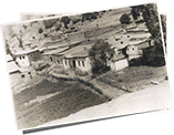
We made a change in this edition. We could not include photographs of the people who lived in our village in our book due to the abundance and lack of choice. We have preserved old and newly taken photographs of residential areas and photographs representing our vegetation and flower cover.
Again with love and respect,
Cahit KARAKULLUKCU
December 2020, Istanbul
 |
Click here to download Cahit Karakullukçu's Uğurtaşı Village bookFree Download |
 |
You can examine the genealogical trees of the Turkish dynasties living in Uğurtaşı village Detail |
 |
Click to view photos .Detail |