Despite the fact that Uğurtaşı village is a highland village by nature, since its foundation, due to the narrowness of the land, it has been visited by higher plains to make th animals morecomfortable, especially during the summer months. The lands in the village were used for wheat, barley and rye cultivation. In addition, the lands within the village were closed to animal entry/walking for winter grass. I am going to talk about the plateaus on the upper elevations that I know their names and have used in the past.
Kolat Strait is the farthest plateau within the borders of our village. In addition to being a plateau, Kolat Strait is also a major transportation hub. During the Ottoman period, in the 1700s and early 1800s, this highland housed a castle for Derbetci and an inn for travelers. It is suitable for both sheep and goat farming.
The old plateau (Kuru plateau) is the most prominent plateau of Uğurtaşı. As far as Kelif ruins are concerned, this is the busiest. In addition to the herds used as houses, there are also enclosures where animals are kept. It was used by both the Greeks and the Turks. In some sources, it is written that more than 60 families spent the summer here.
Çeşmeli (Kroboğar) plateau is rich in water and grass. There are also many ruined shelters and enclosures here.
Öküzyatağı (Rat strait) is located below Kulat where today's transhumant is currently residing.
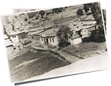
The plateau of Aşağıköy is on the upper elevations of Monamatlı and is still in use, albeit a bit. In fact, it is the only highland where existing structures are preserved. You can see the current state of this plateau in our photos section.
Haşaratka is the largest plateau on the Ligozina side below Kulat. The name of "Haşeratka" is due to the fact that the people of the Haşera (Yeşildere village) built a highland here with our permission. The main source of the great stream passing through Ispel is here.
Cadağalar were not pasturelands in the past, it used to be reaped. Including the area in the direction of the fountain constructed by Ziya Karakullukcu (son of Osman), it is said that it used to be reaped for a fee of 45 days. There is a root of a pine tree, half of which is under the ground, in the stream below the fountain.
The plateau of Uzlu is behind Kavelağ (Yıldız Mountain). Nowadays, transhumance Seferoğlu uses this place for a while in the springs. The Uzs are a Turkic tribe and are known as Oghuzes.
 |
Click here to download Cahit Karakullukçu's Uğurtaşı Village bookFree Download |
 |
You can examine the genealogical trees of the Turkish dynasties living in Uğurtaşı village Detail |
 |
Click to view photos .Detail |