I have done various topographical studies of our village. There are still some places and neighborhoods with their old names. Even in the existing land registry records, these old names were used. I created the map in Annex-22 in order to transfer the names of these places and neighborhoods to younger generations without being forgotten. You can find old or new place and neighborhood names on this map (Annex-22 and Annex-23). You can find the pre-Republican living areas in our village and the old names of the geographical regions that were cultivated in Annex-26.
You can find some local words, sayings, and manias used in and around Uğurtaşı village, Torul District. Initiated by Orhan Karakullukcu, these works were intended to be transmitted to younger generations. Later, they were developed with our input under the heading of Culture.
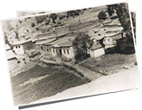
When we examine the structure of Uğurtaşı village, we understand that it was at or above the average Ottoman civilization level in its old period. I believe that this is the result of the coexistence of different cultures. Although the exact construction dates are not known, some of the beautifully constructed arch bridges (at least 200-300 years old) still stand. With its schools, mosques, churches, stone arch fountains, mansions and houses, it was a large settlement with 300-400 households and a population of over two thousand.
During the times when the village was very crowded (1650-1900), there were shops belonging to various occupational groups mentioned in the introduction of the book. These shops were closed one by one in response to the decreasing population with the beginning of the migration from the village. The ones that last the longest are the grocery stores that represent the retail industry, as always. The only thing that can be produced and sold or permute in our village is animal food. Meat and dairy products have always brought money. Again, animal hides and wool were our other valuable products at that time. Their own consumption of flour and products was met through the cultivation of cereals. Barley, rye, or wheat were never grown enough to be sold. Again, vegetables and fruits were sufficient for the consumption of the village. The most produced and delicious vegetables are potatoes, beans, and cabbage. Everything that was not produced in the village, but needed, was obtained with money or by buying it from caravans (utensils and fabric needed for houses, etc.) that came from Trabzon and continued to Erzurum (or vice versa) especially during the summer season. For these needs, besides the caravans, they were also met with round trips to Gümüşhane/Torul and Trabzon/Maçka. In the Republican period, only a coffee house and a grocery store remained open for a short time due to the declining population.
Carts and oxcarts were popular for transportation. There are still remnants of the roads used. These roads were probably used to transport military ammunition during the war years.
When the collapsed structures (house, school, mansion) are examined, it is determined that there are water and sewer lines. Copper pipes are used in drinking water lines. Pipes made of terracotta and called pipes were also used as drinking water and sewage lines. Vineyards and orchards were brought to water by the evlek system, which was built using equidistant curves from very long distances. The evlek system serving the center of Aşağıköy and Uğurtaşı is still in existence. The evlek that came from Pere in Emir district has lost its function today. Uğurtaşı village is very rich in terms of water resources. There are numerous drinking fountains located throughout the city, so the need for drinking water can be met within walking distance. During the republic, fountains built by benevolent village residents solved the water problem on all slopes and mountains of the village (Annex-17, Annex-22).
Our village is also very rich in terms of vegetation. With its abundant flower cover, the whole village looks like a flower garden, especially at the beginning of spring and summer. (See Album) The vegetation of the village started to get stronger and grow especially after 1950. Regions that were once covered with shrubs have become forests today. Two reasons contributed to this. The first is the decrease in the number of people living in the village as a result of increasing immigration after 1950. As a result, vegetation is no longer used as it once was. The second is the abandonment of goat breeding in our village.
I would like to write down the names of some places where they can take a day trip. In the future, the younger generations can use this as a guide to come and visit. Sumela monastery, Zigana Mountain facilities, Limni lake, Art Sun House, Karaca Cave, Mosque Strait, Gravel Lake, Imara Antique City, Santa Antique City and Süleymaniye Neighborhood (Old Gümüşhane).
Süleymaniye District is a place that has witnessed the historical memories of 3 nations in terms of beliefs and cultural values. These nations hosted 3 cultures and 3 beliefs at the same time. Turks, Greeks and Armenians have managed to live together for many years/centuries. Due to this, it has a very unique history among the nations of the world. Due to its proximity to the city center today, this region offers a unique opportunity to promote tourism with intensive participation.
Other places that are home to 3 cultures and 3 beliefs at the same time are the ancient ruins of Santa and the ancient city of Imera. Karaca Cave, on the other hand, is among the most significant caves in Turkey because of its size and depth (256 meters). Stalactites, stalagmites, columns, flagstones, curtain dripstones and dripstone pools have reached large sizes. You can find a larger list of places to visit in Gumushane in the Culture section.
Another feature of our village is the plateaus around it and the festivals held in these plateaus. Rosehip-Pestil Culture and Tourism Festival 24-27 July, Gümüşhane; Kadırga Plateau Festival July 16-17, Kurtün; Kazikbeli Plateau Festival, 18-19 July, Kurtun; Taşköprü Culture and Plateau Festival, 19 July, Yağmurdere; New Plateau (Santa) Festivals are held on July 26, Arsin and Ayeser Plateau Festivals are held within the borders of Torul. You can see the details of the “Gümüshane Highlands and Highland Festivals Calendar” in the Culture section. Some of the plateaus within the village borders are Öküz Bed, Kolat, Kaskarın Düzü, Binnat Yurt and Ayeser. The altitude of all of our plateaus is 2000m and above. Some are around 2500m. Our plateaus are suitable for animal husbandry and have been used since the Ottoman period. Cattle and ovine breeding, which is done in herds, constitutes the main source of livelihood of the local people. The rich flower flora in our plateaus is suitable for beekeeping and is the second source of income for the region. Another aspect of our highlands is the highland festivals that have been going on since ancient times. Although the starting date of the Ayeser plateau festivals, which is close to us, is unknown, it has been held since the Ottoman period. In the documents I obtained from some Greek sources, it is stated that Ayeser festivals have been held since ancient times. Turks and Greeks participated in these festivals together and had fun together. He mentions that at that time, guns were used in the festivities, there were kidnappings, and that's why some festivities ended with a fight. The rapid development of communication and transportation facilities hindered the continuation and richness of these festivities. The markets in the plateau festival area, which is established once a year, have lost their old charm. In the old days, while each village offered its own production for sale in these markets, it was possible to buy those who needed it from the factories and technological materials brought by the vendors from the city. This function of the festivities has lost its appeal, as it is now possible to reach everywhere every day. The entertainment side of the festivities, on the other hand, continues to function, albeit diminishingly. These festivities were the entertainment opportunity that all the local people expected during the periods when the televisions did not start broadcasting and even the radio broadcasts could not reach everywhere. Everyone would wear good and clean clothes and go to Ayeser festivals in groups. On the way, entertainment started with kemençe and horon dances. People from many villages and towns, including Trabzon, Maçka, Tonya and Gümüşhane İkisu, Mescitli (Beşkilise), would come to Ayeser in groups. Here, meals were eaten, horon was played and shopping was done. Raki and pistol shots were the inseparable couple of the old festivities. Today, although these festivals continue to be held under the auspices of the Mayor of Torul, they are not popular. Even though it is 40-50 km away from our region, the Kadırga festivals still continue actively. By participating in these festivities, we can both relieve our longing for the past and ensure the continuation of our traditions.
A memory from the past to the present: Aşağıköy church was used as an inn for a while. The owner of the inn was a Turkish family named Salih who came from Maçka and settled in İstavri. The owner of the inn had three sons of marriageable age in 1750. The children want to marry the three daughters of a Christian family, but the girls' father does not want to give them up because they are Muslim. During a fight, the girls' father dies. Saddened by this situation, Salih Efendi married his orphaned daughters and their sons, and they continued the business. I would like to talk about the visit to Nanak (Evliya) in the late 1940s or early 1950s within the framework of the relations established with the surrounding villages. That year, perhaps more than thirty people walked from the village together and went there. At that time, it was believed that there was a miracle on the pulpit of a church in Nanak or on the ground under the pulpit. This tradition is a feature that has existed since the Greeks. No matter what kind of ailment you had, it was believed that when you lie down for a while in the pulpit area, you will find healing. I wanted to write this story that happened in the past, even though I have not heard of a person who found healing. Finally, I would like to talk about the family ties of the residents of our village with the surrounding villages. In addition to the marriages made with the Greeks in the past, various marriages were made with other surrounding settlements such as Yaglidere, Istilos, Ayliya, Harava and Maçka. We have had relations with three villages close to each other, connected to the center of Gümüşhane. These are Hacıemin/Türkmenli, Yeşilyurt/Kozana and Yeşildere/Haşeratka. Insects have done transhumance in our highland, which is called with their names in our village. Adil Sever from Kozana/Yeşilyurt, in the adjacent neighborhood, married Emiroğlu Ayşe (D.1916) from our village. Rasim Karakullukcu's daughter Samime (D.1931) also came to Kozana/Yeşilyurt and settled in Hacıemin. In short, we should know that the residents of our village also have kinship ties with our surrounding villages. This issue can be further detailed on the basis of identities. You can find a summary of what I was able to find in Annex-31.
Note: You can find the Turkish equivalents of the Ottoman words used while translating Ottoman documents in Annex-29.
 |
Click here to download Cahit Karakullukçu's Uğurtaşı Village bookFree Download |
 |
You can examine the genealogical trees of the Turkish dynasties living in Uğurtaşı village Detail |
 |
Click to view photos .Detail |